Maurice 你好,实现这一点有多种方法,但我推荐的方式是在 Paratext 中使用 BAK(Back Matter,附录)书卷,将一张或多张地图放置在出版物末尾的独立页面上。
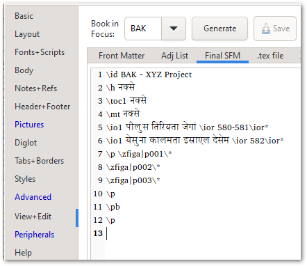
在上方显示的 BAK 书中,有一个适当的标题,\toc1 标记(这将确保“maps”自动添加到出版物的目录页中),以及一个 \io 引言大纲,列出了两张地图。实际上有 3 张图片,但由于我需要第一张地图跨两页显示,我将其切成两半,然后每页放置一半(这就是为什么我有 p001 和 p002)。
地图本身可以添加到此处的 PicList 末尾 - 在这里你可以控制大小、位置、标题(如果需要)等。
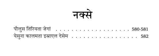
这最终会在地图部分的标题页上显示如下:
然后第 580-581 页将包含第一张地图的两个半部分(此处为裁剪后的图像):
最后一页将显示第二张地图:
如果你想避免使用 BAK 书卷,你可以简单地在正在排版的书卷末尾添加 \zfiga|mapID\*,只要“Frame Size”设置为“Page”或“Full”,它就应该会出现在独立的页面上。
当然,你也可以简单地将一个 PDF 附加到出版物的末尾(请参阅 PTXprint 的 Peripherals 选项卡以了解相关选项)。
选择很多 - 希望其中一种方法适合你的情况。
Hi Maurice, there are different ways of achieving this, but my preferred way is to use the BAK (Back Matter) book in Paratext to place one or more maps on their own page(s) at the back of the publication.
In the BAK book shown above, there is proper title, the \toc1 marker (which will ensure that “maps” is added to the publication’s Table of Contents page automatically), and an \io intro-outline listing the two maps. Actually there are 3 images, but since I needed the 1st map to split across 2 pages, I cut it in half and then placed one half on each page (that’s why I have p001, p002).
The maps themselves can be added to the end of the PicList as shown here - and this is where you would control the size, position, caption (if needed) and so on.
This would end up showing this on the Title page of the maps section:
and then pages 580-581 would contain the 2 halves of the 1st map (cropped image here):
And the last page would show the 2nd map:
If you want to avoid using the BAK book, you could just add the \zfiga|mapID\* at the end of the book you’re typesetting, and as long as the “Frame Size” is set to “Page” or “Full”, it should end up on its own page.
Of course, you can also just tack a PDF on to the end of the publication (see the Peripherals tab of PTXprint for options there).
Plenty of choices - hopefully one of them works well for your context.
机器翻译自 English