Hola, Maurice. Hay diferentes formas de lograr esto, pero mi método preferido es usar el libro BAK (Materiales finales) en Paratext para colocar uno o más mapas en su propia página o páginas al final de la publicación.
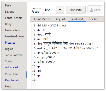
En el libro BAK mostrado arriba, hay un título apropiado, el marcador \toc1 (que asegurará que “mapas” se agregue automáticamente a la página del Índice de la publicación) y un \io intro-outline que lista los dos mapas. En realidad hay 3 imágenes, pero como necesitaba que el primer mapa se dividiera en 2 páginas, lo corté por la mitad y luego coloqué una mitad en cada página (por eso tengo p001, p002).
Los mapas en sí se pueden agregar al final de la PicList como se muestra aquí, y es aquí donde se controlaría el tamaño, la posición, la leyenda (si es necesario) y así sucesivamente.
Esto terminaría mostrando esto en la página de título de la sección de mapas:

y luego las páginas 580-581 contendrían las 2 mitades del primer mapa (imagen recortada aquí):
Y la última página mostraría el segundo mapa:
Si desea evitar usar el libro BAK, simplemente puede agregar \zfiga|mapID\* al final del libro que está componiendo, y siempre que el “Tamaño del marco” esté configurado en “Página” o “Completo”, debería terminar en su propia página.
Por supuesto, también puede simplemente adjuntar un PDF al final de la publicación (vea la pestaña Peripherals de PTXprint para las opciones allí).
Hay muchas opciones; espero que una de ellas funcione bien para su contexto.
Hi Maurice, there are different ways of achieving this, but my preferred way is to use the BAK (Back Matter) book in Paratext to place one or more maps on their own page(s) at the back of the publication.
In the BAK book shown above, there is proper title, the \toc1 marker (which will ensure that “maps” is added to the publication’s Table of Contents page automatically), and an \io intro-outline listing the two maps. Actually there are 3 images, but since I needed the 1st map to split across 2 pages, I cut it in half and then placed one half on each page (that’s why I have p001, p002).
The maps themselves can be added to the end of the PicList as shown here - and this is where you would control the size, position, caption (if needed) and so on.
This would end up showing this on the Title page of the maps section:
and then pages 580-581 would contain the 2 halves of the 1st map (cropped image here):
And the last page would show the 2nd map:
If you want to avoid using the BAK book, you could just add the \zfiga|mapID\* at the end of the book you’re typesetting, and as long as the “Frame Size” is set to “Page” or “Full”, it should end up on its own page.
Of course, you can also just tack a PDF on to the end of the publication (see the Peripherals tab of PTXprint for options there).
Plenty of choices - hopefully one of them works well for your context.
Traducción automática desde English