Halo Maurice, ada beberapa cara untuk mencapai hal ini, tetapi cara yang saya sukai adalah menggunakan buku BAK (Back Matter) di Paratext untuk menempatkan satu atau lebih peta di halaman tersendiri di bagian belakang publikasi.
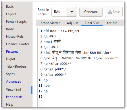
Di buku BAK yang ditunjukkan di atas, ada judul yang tepat, penanda \toc1 (yang akan memastikan bahwa “peta” ditambahkan secara otomatis ke halaman Daftar Isi publikasi), dan \io intro-outline yang mencantumkan dua peta. Sebenarnya ada 3 gambar, tetapi karena saya perlu peta pertama terbagi menjadi 2 halaman, saya memotongnya menjadi dua bagian dan kemudian menempatkan satu bagian di setiap halaman (itulah mengapa saya memiliki p001, p002).
Peta-peta itu sendiri dapat ditambahkan ke akhir PicList seperti yang ditunjukkan di sini - dan di sinilah Anda dapat mengontrol ukuran, posisi, keterangan (jika diperlukan), dan sebagainya.
Ini akan berakhir dengan menampilkan ini di halaman Judul bagian peta:
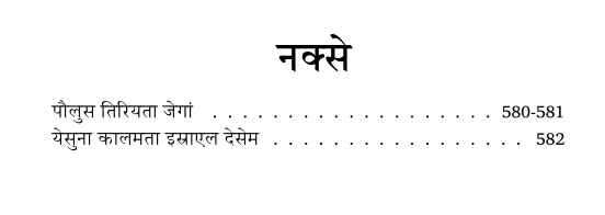
dan kemudian halaman 580-581 akan berisi 2 bagian dari peta pertama (gambar dipotong di sini):
Dan halaman terakhir akan menampilkan peta kedua:
Jika Anda ingin menghindari penggunaan buku BAK, Anda cukup menambahkan \zfiga|mapID\* di akhir buku yang sedang Anda tata letak, dan selama “Frame Size” diatur ke “Page” atau “Full”, seharusnya akan berakhir di halamannya sendiri.
Tentu saja, Anda juga dapat menghubungkan PDF ke akhir publikasi (lihat tab Peripherals di PTXprint untuk opsi di sana).
Banyak pilihan - semoga salah satunya bekerja dengan baik untuk konteks Anda.
Hi Maurice, there are different ways of achieving this, but my preferred way is to use the BAK (Back Matter) book in Paratext to place one or more maps on their own page(s) at the back of the publication.
In the BAK book shown above, there is proper title, the \toc1 marker (which will ensure that “maps” is added to the publication’s Table of Contents page automatically), and an \io intro-outline listing the two maps. Actually there are 3 images, but since I needed the 1st map to split across 2 pages, I cut it in half and then placed one half on each page (that’s why I have p001, p002).
The maps themselves can be added to the end of the PicList as shown here - and this is where you would control the size, position, caption (if needed) and so on.
This would end up showing this on the Title page of the maps section:
and then pages 580-581 would contain the 2 halves of the 1st map (cropped image here):
And the last page would show the 2nd map:
If you want to avoid using the BAK book, you could just add the \zfiga|mapID\* at the end of the book you’re typesetting, and as long as the “Frame Size” is set to “Page” or “Full”, it should end up on its own page.
Of course, you can also just tack a PDF on to the end of the publication (see the Peripherals tab of PTXprint for options there).
Plenty of choices - hopefully one of them works well for your context.
Diterjemahkan secara otomatis dari English